
Ember drift represents one of nature’s most devastating and unpredictable phenomena during extreme wildfire events, transforming contained blazes into unstoppable infernos that leap across firebreaks and challenge suppression efforts.
🔥 The Hidden Catalyst Behind Catastrophic Fire Spread
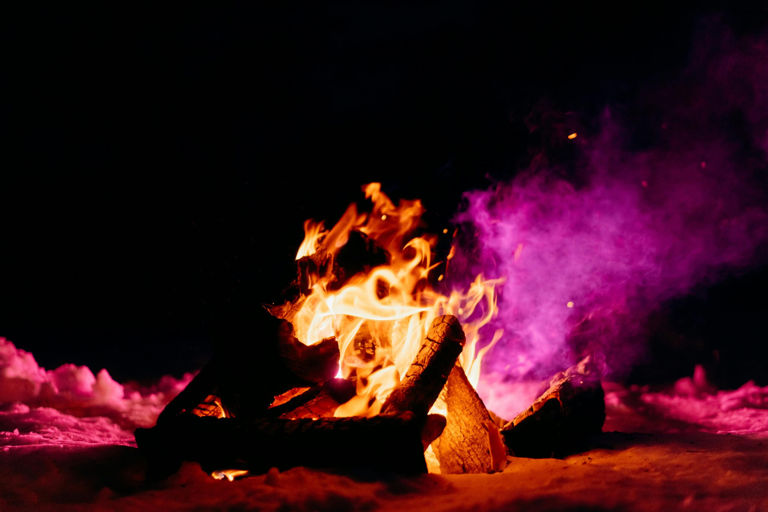
When wildfires reach extreme intensity levels, they generate more than just towering flames and suffocating smoke. Among the most dangerous byproducts of these conflagrations are firebrands—burning embers that detach from the main fire front and travel through the air, sometimes covering extraordinary distances. This phenomenon, known as ember drift or spotting, has been responsible for some of the most devastating fire disasters in recorded history.
Ember drift occurs when combustible materials from the primary fire become airborne. These glowing fragments, ranging from tiny sparks to substantial chunks of burning debris, are lofted by convective columns and carried by prevailing winds. The distance these embers travel depends on multiple factors including their size, shape, density, wind speed, and atmospheric conditions. Small embers may extinguish quickly, while larger firebrands can maintain their heat for extended periods, igniting new fires miles ahead of the main fire front.
The Physics Behind Ember Generation and Transport
Understanding ember drift requires examining the complex physics governing their creation and movement. During extreme fire behavior events, intense heat generates powerful convective columns that can reach several kilometers into the atmosphere. These updrafts create a chimney effect, pulling air from the surrounding environment and lifting burning materials skyward.
The combustion process itself plays a crucial role in ember production. As fire consumes vegetation and structures, it creates fragments through several mechanisms: thermal degradation that causes materials to break apart, explosive release of volatiles that fragments burning material, and physical forces from wind and convection that tear pieces from the burning mass.
Once airborne, embers follow trajectories determined by aerodynamic properties and atmospheric conditions. Larger, denser particles fall relatively quickly, creating spot fires close to the main fire. Lighter materials, particularly those with favorable shapes for flight, can travel extraordinary distances. Research has documented embers traveling up to 35 kilometers ahead of major fires, though most spotting occurs within a few kilometers of the fire front.
Environmental Conditions That Amplify Ember Drift Danger
Not all fire weather conditions create equal ember drift hazards. Certain atmospheric configurations dramatically increase both ember production and transport distances, creating perfect storm scenarios for fire spread.
Wind Patterns and Velocity
Strong, sustained winds serve as the primary transportation mechanism for embers. However, it’s not just surface winds that matter. The entire vertical wind profile influences ember trajectories. Low-level jet streams can accelerate ember travel, while wind shear at different altitudes affects how embers disperse across the landscape.
Gusty, erratic winds present particular challenges. Sudden wind shifts can redirect ember showers into previously safe areas, catching firefighters and residents off guard. Downslope wind events, such as Santa Ana winds in California or Foehn winds in Europe, create especially hazardous conditions by combining high velocity with low humidity.
Atmospheric Stability and Pyroconvection
Unstable atmospheric conditions allow convective columns to develop greater height and intensity, lifting embers higher and extending their potential travel distance. When fires generate enough energy, they can create pyrocumulonimbus clouds—thunderstorms produced by the fire itself. These fire-generated weather systems can loft embers to extreme altitudes and distribute them across vast areas.
During stable atmospheric conditions, smoke and heat are trapped at lower levels, which can still produce dangerous ember drift but over shorter distances. Each scenario presents unique challenges for prediction and response.
Vegetation Type and Fuel Characteristics in Ember Production 🌲
Different vegetation types produce embers with varying characteristics. Understanding these differences helps fire managers anticipate spotting potential in different ecosystems.
Coniferous forests, particularly those with species like eucalyptus, pine, and fir, are prolific ember generators. These trees contain resinous compounds that burn intensely and produce lightweight bark fragments ideal for long-distance transport. Eucalyptus bark, in particular, naturally sheds in ribbon-like strips that become dangerous firebrands when ignited.
Chaparral and shrubland ecosystems generate smaller but numerous embers. While individual firebrands may not travel as far, the sheer volume can overwhelm suppression resources and ignite multiple spot fires simultaneously.
Grasslands typically produce fewer embers capable of long-distance spotting, but under extreme conditions, dried vegetation clumps can break free and become airborne. The real danger in grasslands comes from the rapid rate of spread once spot fires ignite in receptive fuels.
Human-Made Structures as Ember Generators
When wildfires reach the wildland-urban interface, structures themselves become significant sources of firebrands. Buildings contain numerous materials that fragment during combustion, creating embers with different flight characteristics than natural fuels.
Wood-frame construction produces abundant embers from roof materials, siding, and structural elements. Composite materials, asphalt shingles, and even certain types of insulation can generate burning debris. Unlike natural fuels that may extinguish relatively quickly, structural materials can maintain combustion for extended periods.
The configuration of buildings affects ember production patterns. Structures that collapse suddenly release massive quantities of burning debris simultaneously, while those that burn more gradually provide a sustained ember source over time.
Documented Case Studies of Extreme Ember Drift Events 📊
Historical fire events provide sobering evidence of ember drift’s destructive potential and offer valuable lessons for future preparedness.
Camp Fire, California (2018)
The Camp Fire demonstrated catastrophic ember drift under extreme conditions. Strong winds combined with abundant dry fuels created a firestorm that destroyed the town of Paradise, California. Ember showers ignited structures throughout the community faster than residents could evacuate. Survivors reported embers the size of dinner plates landing blocks ahead of the main fire, igniting multiple homes simultaneously. The fire killed 85 people and destroyed over 18,000 structures.
Black Saturday Fires, Australia (2009)
These fires showcased extreme ember drift under some of the most severe fire weather conditions ever recorded. Temperatures exceeded 46°C (115°F), humidity dropped below 10%, and winds gusted over 100 km/h. Embers traveled up to 35 kilometers ahead of fire fronts, creating a spotting cascade that overwhelmed suppression efforts. The fires killed 173 people and destroyed thousands of homes across Victoria.
Fort McMurray Fire, Canada (2016)
This boreal forest fire demonstrated that extreme ember drift isn’t limited to Mediterranean climates. Despite occurring in northern latitudes, the fire exhibited extreme behavior including massive ember showers that leapfrogged the Athabasca River, a natural barrier firefighters hoped would check the fire’s advance. The ember transport across this water barrier illustrated how ineffective traditional firebreaks become under extreme conditions.
Predicting and Modeling Ember Drift Behavior
Advances in fire science have improved our ability to predict when and where dangerous ember drift may occur, though significant uncertainties remain.
Computer models now incorporate ember generation rates, aerodynamic properties, atmospheric conditions, and terrain features to estimate spotting distances and ignition probabilities. These models help fire managers anticipate where spot fires may develop and position resources accordingly.
However, modeling ember drift remains challenging due to the chaotic nature of fire behavior and the countless variables influencing ember trajectories. Small changes in wind speed, humidity, or fuel moisture can dramatically alter outcomes. Additionally, the stochastic nature of ignition—whether an ember actually starts a fire when it lands—introduces another layer of uncertainty.
Remote sensing technologies, including infrared cameras mounted on aircraft and satellites, now allow near-real-time detection of spot fires. These systems can identify thermal signatures from newly ignited fires, enabling rapid suppression response before they grow beyond initial attack capabilities.
Defense Strategies Against Ember Attack 🛡️
Protecting structures and communities from ember drift requires multilayered defense strategies addressing both the built environment and surrounding landscape.
Home Hardening Measures
Research demonstrates that embers cause the majority of structure losses during wildfires, not direct flame contact. Therefore, ember-resistant construction significantly improves survival probability.
- Installing Class A fire-rated roofing materials eliminates a primary ember ignition point
- Screening vents with 1/8-inch metal mesh prevents embers from entering attics and crawl spaces
- Using tempered or multi-pane windows reduces breakage from radiant heat
- Maintaining ember-resistant zones within five feet of structures removes ignitable materials
- Enclosing eaves and soffits eliminates spaces where embers can accumulate
Defensible Space and Fuel Management
Creating and maintaining defensible space around structures provides multiple benefits. It reduces fire intensity approaching structures, limits ember generation from nearby vegetation, and provides safe working areas for firefighters defending homes.
Fuel management zones should extend at least 30 meters (100 feet) from structures in most situations, with greater distances required on slopes or in high-hazard fuel types. Within these zones, vegetation should be reduced, carefully selected for fire resistance, and maintained to reduce fuel loading.
The Role of Community Planning in Ember Drift Mitigation
Individual property protection measures, while essential, prove insufficient without coordinated community-level planning. Neighborhoods designed with fire-resilient principles significantly outperform those without such considerations.
Community design elements that reduce ember drift vulnerability include: adequate spacing between structures to prevent house-to-house ignition chains, strategic placement of fuel breaks and green spaces to interrupt fire spread, multiple evacuation routes to ensure escape options remain available, and water supply systems designed to maintain pressure during extended fire sieges.
Land use policies that restrict development in extreme fire hazard areas or mandate higher construction standards in wildfire-prone zones create long-term resilience. While politically challenging, such policies prevent the continued expansion of at-risk communities into fire-adapted ecosystems.
Climate Change and Future Ember Drift Scenarios 🌡️
Climate projections indicate increasing frequency and severity of fire weather conditions conducive to extreme ember drift events. Rising temperatures, extended drought periods, and altered precipitation patterns are lengthening fire seasons and expanding areas vulnerable to catastrophic wildfires.
Research suggests that the number of days with critical fire weather conditions has already increased significantly across many regions. This trend is expected to continue, with some climate models projecting doubling or tripling of extreme fire weather days by mid-century in certain areas.
The implications for ember drift are profound. More frequent extreme fire weather means more opportunities for long-distance spotting events. Additionally, vegetation stress from persistent drought increases fuel availability and ember generation potential. Fire-adapted plant communities may shift geographically, introducing ember-prolific species to previously lower-risk areas.
Emerging Technologies for Ember Detection and Suppression
Innovation in fire management technologies offers new tools for addressing ember drift challenges. Artificial intelligence systems now analyze satellite imagery and weather data to predict high-risk spotting conditions hours or days in advance, allowing preemptive resource deployment.
Drone technology provides unprecedented situational awareness during ember drift events. Unmanned aerial vehicles equipped with thermal cameras can rapidly survey large areas, identifying spot fires in their incipient stages when suppression remains feasible. Some experimental systems even deliver fire suppressant to spot fires autonomously.
New suppressant technologies specifically target ember ignition mechanisms. Gel-based products create protective coatings on structures and vegetation that prevent ember ignition. Long-duration retardants applied to homes before fire arrival provide hours of protection against ember showers.
Living With Fire: Cultural Adaptation to Ember Drift Reality 🏘️
Ultimately, reducing ember drift risk requires cultural shifts in how communities relate to fire-prone landscapes. Indigenous fire management practices offer valuable lessons, demonstrating how regular, low-intensity burning reduces fuel accumulations and creates landscape mosaics more resistant to catastrophic fire spread.
Modern fire-adapted communities embrace fire as an inevitable landscape process rather than something to be completely excluded. This paradigm shift influences everything from architecture and landscaping to evacuation planning and community preparedness programs.
Education plays a crucial role in this adaptation. Residents who understand ember drift mechanisms and their role in structure loss make better decisions about home hardening investments, defensible space maintenance, and evacuation timing. Community workshops, demonstration projects, and peer-to-peer learning networks spread knowledge and build collective capacity for fire resilience.
The Path Forward: Integrated Ember Drift Management
Addressing the ember drift challenge requires integration across multiple domains: science must continue improving our understanding of ember generation, transport, and ignition mechanisms. Engineering must develop and refine construction techniques and materials that resist ember ignition. Policy must create frameworks that incentivize risk reduction and guide development away from highest-hazard areas.
Fire management agencies need resources and training to address ember drift scenarios effectively. Traditional firefighting tactics prove inadequate when fires generate massive ember showers. New approaches emphasizing early detection, rapid initial attack on spot fires, and strategic structure triage during ember storm events must become standard practice.
Collaboration between researchers, fire managers, planners, and communities creates opportunities for innovation and learning. Each extreme fire event, while tragic, provides data that refines our understanding and improves future preparedness. Sharing these lessons across regions and nations accelerates the global capacity to coexist with fire-prone landscapes.
The fury of ember drift during extreme fire behavior events represents one of the most formidable challenges facing fire-prone communities worldwide. Yet this challenge is not insurmountable. Through combination of scientific understanding, technological innovation, thoughtful planning, and community engagement, we can significantly reduce ember drift vulnerability. The path forward demands sustained commitment and investment, but the alternative—continuing cycles of catastrophic loss—is unacceptable. By unleashing our collective ingenuity and resolve, we can meet the fury of ember drift with resilience and adaptation.